Hike and Fly - Kilimanjaro
Daniel Mayall talks about the historic expedition to Kilimanjaro
Hike and Fly - Kilimanjaro
Daniel Mayall talks about the historic expedition to Kilimanjaro
We officially created a group and started exchanging messages about potential flights in Africa in April 2023, although I (Daniel Mayall), Rafael Saladini, and Rafael Souto had already been researching the Kilimanjaro flight—each on our own—for quite some time. And it was precisely this shared interest that gave the idea momentum. We ruled out other locations we were considering and focused solely on this great Hike & Fly adventure.
The trip’s organisation received crucial support from Linda Willemse of Paraglide Kilimanjaro, who has over 25 years of experience organising this type of expedition. Throughout our planning meetings, we could see the professionalism with which she handled the matter: we would have three mountain guides, each with over 400 ascents to the summit of Kilimanjaro. Our paragliding guide would be none other than South African Pierre Carter—a three-time X-Alps participant—who had just returned from two Hike & Fly expeditions: one to Aconcagua in Argentina and another to Mount Vinson in Antarctica.
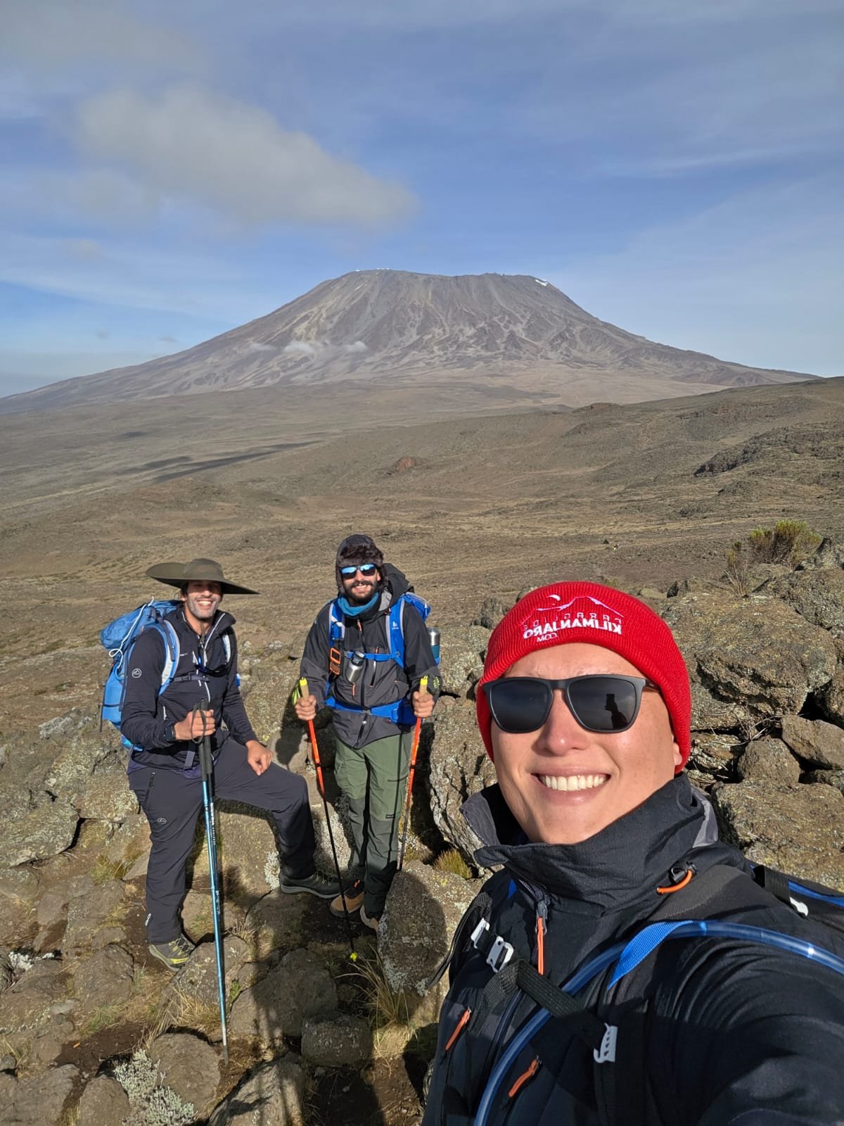
With a team of this caliber, we turned our focus to preparation. Each of us chose a different path. The Rafas, who were already fully immersed in the world of Hike & Fly, with three Trans Capixabas under their belts, continued with the training they were already accustomed to. I, who was way behind in terms of fitness, opted for cycling and weight training, knowing that I might face more difficulties than they did. What was crystal clear to all of us was that physical strain at high altitudes and the effects of altitude are often unpredictable. Therefore, regardless of our prior training, we would only know what awaited us once we began the ascent.
The first few days were relatively calm. We walk wandering, ou pole-pole, as the local guides say. The logic is simple: with little time to acclimatise, it is necessary to generate the maximum possible energy to attack the cume. On the first night, we slept at 2,600 m ASL. On the second night, after an entire day of walking, we slept at 3,450 m ASL. On the third day, we have the first contact with the real altitude, exceeding 4,000 m ASL for a long time, so as not to end, we descend and sleep at 3,900 m ASL.
Today we have to make our first important decision. In advance, no application is suggested in our guide indicating winds above 25 km/h at peak speeds, which, as you understand in advance, generally means even stronger cracks. We would have to choose between staying more at night without camping and acclimatising in more calm or continuing to the last campsite – Kibo Hut – at 4,600 m ASL, where the only source of effective water is 3 km away. Fortunately, next year, Camp 3 had a rock where the internet worked perfectly. When we checked other preview sites, we saw that the intensity of the wind was not too strong in two four models available: GFS, ECMWF, ICON and Meteoblue. Accrediting the best time of the forecast, we choose to continue to check the next possible time, in order to take advantage of any situation that arises.
We go to the last campsite at 1:00 p.m. At that time, we still did not have to confirm the authorisation for decollaging. If we were to really climb, we would need to eat and rest, so we would get up at 11 pm to start climbing in the middle of the night. Crediting a happy ending, we left everything soon and, using a satellite phone (there was no internet signal), we met up with Linda at 5 pm. It was time that we finally had some encouraging news: the authorities have granted the release in writing! We barely managed to contain the animation. The best thing to do was to start going up immediately, but let's keep calm and uncombined focus. We tried to sleep (or as much as anxiety allowed) and set the alarm for 11 pm.
We woke up with a different feeling. The relentless cold that accompanied us now, with temperatures below zero at night, seemed to have given us a truce. The sky was crescent, and it was possible to see the stars shining brightly in the sky. We face an uninterrupted climb of 1,000 m in a difficult, only rock and volcanic belt. As the inclination was high, we needed to continue in an infinite zig-zag along the edge of the old vulcão.
For five hours of climbing with very few breaks. When we look at the end of the journey, we understand why the temperature was more pleasant: there was a thermal inversion at the level of two 5,000 m ASL. Only when we surpass that height do we have contact with the real temperature that would await us for the rest of the climb. The cold and wind give a thermal sensation below two negative 10 degrees. The hoses of the two camelbacks freeze and become useless. We could only count on the thermal carafes and as the cha that guided you to us. As we looked down, we couldn't see the camp because of the strong inversion that hit the bottom of the mountain. At altitude, they begin to show their faces. Our legs do not accompany us, and each step becomes more difficult. To improve, the higher we go, the steeper the climb and the more zig-zag we need to do. The last stretch was the worst: a climb to 5,500 m ASL and nothing to see at the end of the climb.
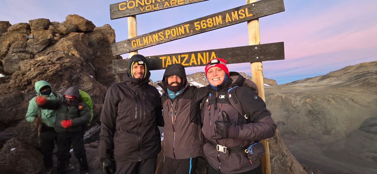
It was only when we came to the edge of the crater that it emerged into the first light on the horizon. It was the dawn of Africa. With that light, we managed to read what was written on the plaque that received us: Gilman’s Point – 5,681 m ASL. This clarity, which, on the one hand, gives us new energy, also brings us an implacable truth: we are still 2 km away and 214 m high from Uhuru Peak. At that moment, there was no more strategy. Each item would have to be better to check out and return for about 15 minutes to the decollage location.

According to our schedule, we were all supposed to be in Moshi on January 24. The 25th would be set aside for the briefing, inspection of flight and camping equipment, configuration of electronics—including landing sites, airspace, radio frequencies, GPS trackers, and emergency contacts—as well as final adjustments.
Mount Kilimanjaro is Africa’s highest mountain, with an elevation of 5,895 m ASL. The mountain is a dormant volcano whose origins date back over a million years. Its highest point is Uhuru Peak, though the mountain also features another peak of striking beauty, called Mawenzi, at 5,149 m ASL. Both peaks are connected by a high-altitude plateau popularly known as the “saddle.” Another relevant fact, much discussed here in Tanzania, is that Mount Kilimanjaro is the world’s tallest mountain in terms of free height—that is, from its base to the summit—since it rises vertically from an altitude of 700 m ASL and is not part of any mountain range.
It seems crazy to go all the way to Africa to paraglide without authorisation from the authorities. And indeed it is: we had everything sorted out, but we were caught off guard a few weeks earlier by a helicopter crash that caused the authorities to close all airspace and cancel all previously granted authorisations until further notice. This meant we literally had to start from scratch, under new regulations that hadn’t even been written yet. Linda played a crucial role here, sparing no effort to secure the permit—she even took a paraglider wing to government officials and inflated it so they could understand how a paraglider takes off. The fact is, we had no alternative: we had to begin our ascent and trust that the authorisation would come.
We began our journey on January 26, 2026, at 9:30 a.m. The first leg would be by car to the Rongai Route access point, in the northeastern part of the Park. From there, it would be four days of climbing, ranging from light to moderate intensity, with a focus on acclimatisation. In this process, we still had to take into account the two main variables that, up to that point, were major unknowns for us: the takeoff authorisation and the weather conditions. These uncertainties would literally accompany us until the very end, as I will detail below.
Rafael Souto reacted best. For him, reaching Gilman's Point and seeing that the wind was gentle was the necessary boost of energy. He led the way along with Pierre Carter. Rafael Saladini had a difficult climb to Gilman's, but managed, with sheer determination, to keep walking – pole-to-pole – towards Uhuru Peak. I, who until then had been in good physical condition, was the one who had the most difficulty. Because I didn't fully understand the distance we still had to walk along the crater rim, I ended up spending more energy than I should have on the climb to Gilman's. This cost me dearly. I walked at the limit of my physical strength, stopping every three or four steps. I almost gave up twice when I sat down to rest and almost fell asleep. If it weren't for the guide who accompanied me, I might not have been able to complete the climb.
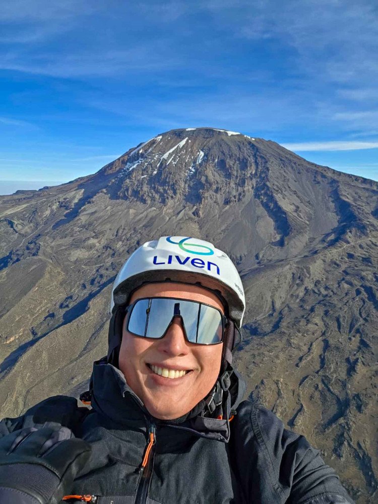
Each in their own way and at different times, we reached the summit. 5,895 m ASL: We were officially on top of Africa! But there was no time to celebrate. Our goal was not just to climb; We were there to take off! Our guide Pierre's instructions were clear: “The wind is perfect, we can't waste any time! Conditions change rapidly on the mountain. Reach the summit and come to the takeoff area as quickly as possible. Your equipment will be there waiting to be checked!”
When I arrived at the takeoff area, I was completely exhausted. To my surprise, the Rafas were already checked, harnessed, and ready to take off. The wind was perfect, and there was nothing more to wait for. I just had time to get close to them and make the wish that every pilot makes to their winged brothers: “Have a good flight!” And so, quickly, the two took off. They were even graced with a thermal right on the ramp and managed to turn and see Mount Kilimanjaro in all its splendour.
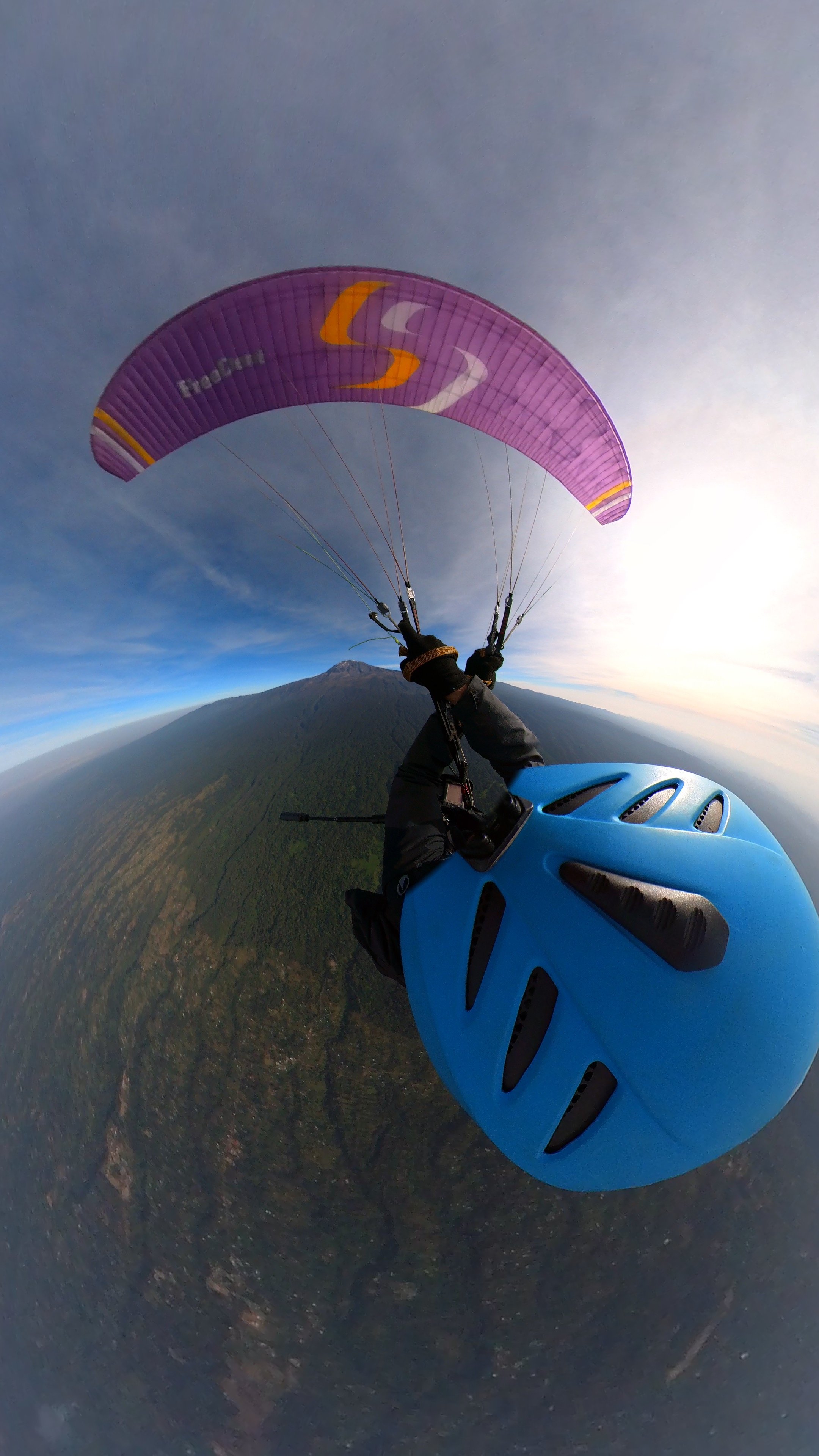
Although I wanted to admire the beauty of my friends' flight, there was no time to lose. Pierre reiterated, “Not to rush you, but the wind is changing. If you delay, you might end up having to walk down!” Tired as I was, he didn't even need to repeat himself. I connected to the equipment that the guides had already opened. I checked the lines and inflated. The wind was really quite crosswind, almost tailwind at that moment. I tried to keep the sail above my head, but with that wind, it wasn't possible. I thought to myself: "Will the wind change when it's my turn? Will I have to walk down?" I lowered the sail and took a deep breath. "I just need a little puff," I thought. Almost instantly, I felt the wind hitting my back again. It was the moment! I pulled, and the sail came gently over my head. It was only a few steps, and I was in flight. I did it! I took off from Mount Kilimanjaro! It was an indescribable feeling: a mixture of euphoria and contemplation. I was laughing and crying at the same time!
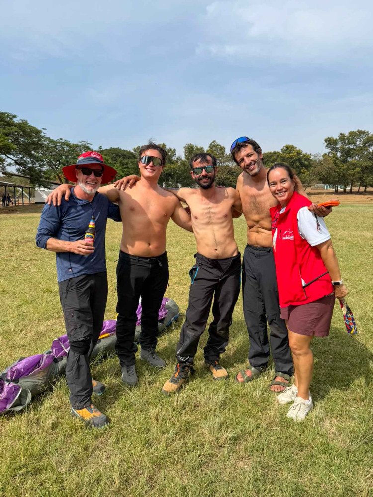
The flight was a real "nail-biter" of just over an hour. Upon landing, Linda Willemse and Joana Garcia, my fiancée, were waiting for us. She had climbed with us to Camp 3 but had to descend due to altitude sickness. When I landed, I had one of the craziest sensations I've ever felt on a flight. It felt like I had crossed a portal. I didn't feel tired or cold. There was no indication that, just an hour before, I had been experiencing the most extreme situation I had ever lived through. The summit seemed distant, and the suffering, something from a past life. I talked to the two Rafas, and they were both feeling the same thing. That's great – that gave us more energy to celebrate!
This feat, the way it happened, will never leave our minds and hearts. We were the first Brazilians to climb and take off from the summit of Mount Kilimanjaro: THE TOP OF AFRICA!
Daniel Mayall flew the APOLLO 3 LIGHT glider
Rafael Souto Alves flew the MERLIN glider